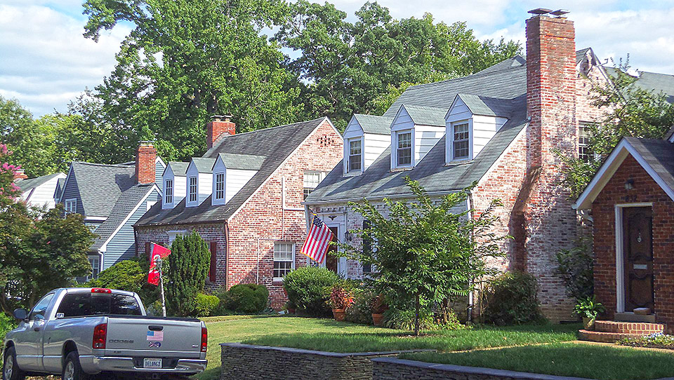
Photo: Homes in the Aurora Highlands Historic District, Arlington, VA. The District was listed on the National Register of Historic Places in 1974. Photographed by wikipedia username: Farragutful, own work, 2014, [cc-3.0], accessed September, 2022.
Photo: Homes in the Aurora Highlands Historic District, Arlington, VA. The District was listed on the National Register of Historic Places in 1974. Photographed by wikipedia username: Farragutful, own work, 2014, [cc-3.0], accessed September, 2022.
Initial development in Aurora Highlands [†] consisted of multiple parcels that were subdivided between 1896 and 1930. These early subdivisions were oriented toward 23rd Street South, the major road in the area that ran from the streetcar line (present-day Eads Street) to Mount Vernon Boulevard (present-day Arlington Ridge Road). Subdivisions platted in 1930 expanded the neighborhood to its current boundaries of 16th Street South on the north, South Eads Street on the east, 26th Street South on the south, and South Ives and South Joyce Streets on the west. The slow development was accelerated as World Wars I and II (1914-1918/1941�1945) ushered in an unprecedented need for housing surrounding the nation's capital. After World War II, the subdivisions were resubdivided to fill empty tracts between existing lots. Resubdivision again occurred as late as 1984. Thus, Aurora Highlands is characterized by three phases of suburban development, all spurred by the influx of center-class residents.
Today, Aurora Highlands contains a variety of architectural styles, forms, and building types, which are primarily domestic buildings. Architectural styles include early-twentieth-century Colonial Revival, Craftsman, Tudor Revival, and Modern Movement. The early- to mid-twentieth-century buildings often exhibit vernacular, less detailed interpretations of the fashionable styles popular throughout the nation, while the later more modest development reflects the solid center-class nature of the commuter suburb. Typical forms include Bungalows, American Foursquares, Cape Cods, and Ranch houses. Aurora Highlands contains seven dwellings that have been positively identified as prefabricated kit or mail-order houses. Building types include single dwellings, twin dwellings, duplexes, apartment buildings, religious buildings, educational buildings, and commercial buildings. Although a number of the dwellings have replacement materials and/or modest additions, the overall integrity of the neighborhood remains substantially intact.
The two oldest buildings in Aurora Highlands were constructed prior to the first subdivisions in what was to become Aurora Highlands. Located at 721 and 822 20th Street South, these two dwellings reflect domestic forms and detail common to Arlington County in the late nineteenth century. The property on which the two buildings are located was purchased by the Addison Heights Company in 1895 in anticipation of development of the neighborhood as a planned suburb. The development company sold the improved lots in 1896. Historic maps and the 1896 deeds of sale support the existence of these two buildings prior to the subdivision of the neighborhood in 1896.
The name Aurora Highlands comes from an amalgamation of the original three subdivisions: Addison Heights, Aurora Hills, and Virginia Highlands. The area was first subdivided by the Addison Heights Company, under the direction of President Walter D. Addison, in 1896. This area included 16th Street South (originally Clements Avenue) at the north end, South Fern Street (originally Cheston Avenue) at the east end, 23rd Street South (originally Frazier Avenue) at the south end, and South Arlington Ridge Road (originally Mount Vernon Avenue) at the west end. Despite the subdivision of portions of the neighborhood in 1896, no improvements were constructed until after the turn of the twentieth century.
The Aurora Highlands Historic District in Arlington County, Virginia, is significant as a residential commuter suburb of Washington, D.C. The community grew with the arrival of the commuter railways, buses, and automobiles during the early twentieth century. Developed between 1896 and 1930, Aurora Highlands was formed from three subdivisions under the direction of more than twenty operative builders and developers, who expanded on the initial subdivision plan of the Addison Heights Company. Aurora Highlands, along with its surrounding neighborhoods, documents the residential and commercial development of southern Arlington County during the first half of the twentieth century. The majority of the dwellings were constructed between the early 1920s and the late 1950s, providing much-needed housing for government employees, particularly those stationed at the newly constructed Pentagon. Although developed independently by numerous developers and builders, the historic district illustrates the principles of neighborhood planning espoused by the Federal Housing Administration by providing accessibility to public transportation, employment, and shopping, and incorporating schools, parks, and churches within a unified community. Aurora Highlands individually reflects the nationwide changes in residential building forms, styles, and materials from the first half of the twentieth century, and unlike its neighboring communities of Aurora Hills and Virginia Highlands, features a limited variety of building types. The neighborhood retains a substantial number of early- to mid-twentieth-century single-family and multi-family dwellings representing popular styles and forms including the Craftsman/Bungalow, Cape Cod, Colonial Revival, American Foursquare, Tudor Revival, and Modern Movement. Educational, religious, and commercial buildings, as well as two landscaped parks enhance the residential community. Aurora Highlands is significant under the themes of architecture and community planning/development with the period of significance extending from circa 1870 to 1957. Beginning in 1958, the architectural styles and forms in Aurora Highlands change, therefore, the period of significance only extends to 1957. Aurora Highlands is being nominated under the Multiple Property Nominations, Historic Residential Suburbs in the United States, 1830-1960.
Aurora Highlands is a commuter community that developed to support the expanding center-class suburban population of Washington, D.C. during the first half of the twentieth century. The Mount Vernon Electric Railway, which ran from Mount Vernon to Washington D.C. by 1896 when the neighborhood was first platted, traveled parallel to Cheston Avenue (present-day South Fern Street) at the point of present day South Eads Street. The railway originally served this commuting suburb, which is located west of present-day Jefferson Davis Highway and the neighboring communities of Virginia Highlands and Aurora Hills. Surrounded by major automobile thoroughfares and accessible by bus lines, Aurora Highlands was firmly established as a commuting suburb of Washington, D.C. by the mid-1950s.
Historically a farming area, the first tract developed in what would become Aurora Highlands was platted in 1896 by a "subdivider," who acquired and surveyed the land, developed a neighborhood plan, laid out the building lots and often the roads, and provided amenities. Newspaper articles from the period that announced the platting of the neighborhood recount that the development company had initially planned on enhancing the marketability of their new subdivision by building houses on a small number of lots; however, the lots offered for sale by the real estate company were as a rule unimproved. Although the prices of the unimproved lots were reasonably priced for center-income buyers, and the neighborhood was easily accessible by the railway, development was remarkably limited. By the 1920s, with the expansion of the federal government and the advent of the automobile, construction of single dwellings commenced in Aurora Highlands under the direction of numerous developers and builders; by 1935, 60% of the subdivided lots were improved. The principles of the Federal Housing Administration's (FHA) neighborhood planning ideals had a unifying influence on the growth of this community. The FHA encouraged large-scale development under the direction of "operative builders," who expanded on the efforts of nineteenth-century "subdividers" by further improving the neighborhood by constructing houses. The FHA set forth requirements for new subdivisions: the location must exhibit an active demand for houses; that location must be a suitable site; the site must be accessible by public transportation with access to schools, employment, and shopping; the development must be compliant with city, county or regional plans and regulations; and the development must guarantee it is a sound financial venture. Development from the 1930s through the late 1950s exhibits these FHA requirements for planned communities, transforming Aurora Highlands into a unified planned community consisting of three separate subdivisions.
The suburban neighborhood of Aurora Highlands is substantial concentration of domestic architecture from the early to mid-twentieth century, representing the Colonial Revival, Craftsman, Tudor Revival, and Modern Movement styles that were popular during the period. Local builders and architects speculatively built the majority of residences in Aurora Highlands. The earliest houses erected within Aurora Highlands were concrete structures with Foursquare forms and Craftsman-style dwellings with Bungalow forms. As the neighborhood continued to grow, Colonial Revival became the prominent style. Most dwellings are set back from the street and were later augmented by sun porches, side wings, and rear additions. Aurora Highlands exhibits a limited variety of building forms, including Cape Cod, Bungalow, Minimal Traditional, and American Foursquare.
Various public works programs operating out of Washington, D.C. during the Great Depression (1929-1941) followed by the need for an increased work force during World War II, led to a population surge in the nation's capital that spilled over into the suburbs. As the population of Arlington grew, residential construction in Aurora Highlands surged during the early 1940s. A substantial number of new houses filled lots within existing subdivision plats, as well as in portions of the neighborhood that were resubdivided to provide more, albeit smaller lots. The dwellings were modest with minimal ornamentation, constructed mainly by local realty enterprises offering modest Cape Cods and two-story houses with rectangular forms ornamented in a variety of styles, including the Colonial Revival and Tudor Revival styles.
Construction of single dwellings occurred throughout the neighborhood during the early 1950s, reflecting the need for housing in the post-war years. By the mid-1950s, the majority of land in Aurora Highlands was developed. Facilities located within and adjacent to the boundaries of Aurora Highlands have created a self-sufficient community. Within the neighborhood, two schools, three churches, and two parks provide spaces for recreational activities and community events. The South Eads Street commercial strip bounds the neighborhood. These amenities, although outside the historic district
Following a referendum among its citizens in 1846-1847, Alexandria County, including the City of Alexandria and present-day Arlington County, voted to return to the Commonwealth of Virginia. Alexandria remained the area's center of commerce, trade, and domestic development, spurred on by the construction of canals, railroads, and trading routes. Improved roadways and the railroad further encouraged commercial prosperity by providing the necessary links between farms and commercial centers. The railroads, however, did not cross the river until after the Civil War (1861-1865), when Union forces laid rails along the Long Bridge, which is now the site of the 14th Street Bridge.
In the decades leading up to the Civil War, the population of Alexandria County continued to grow reaching 9,573 residents in 1830. By 1840, the population increased by only 394 residents. Census records show a steady increase from 10,008 in 1850 to 12,652 in 1860. Those living in the rural part of the county in this period remained in the minority, numbering 1,332 residents in 1830 and 1,508 residents in 1840, with a decline to 1,274 residents in 1850. The 1850 census listed most of those employed in rural areas as farmers or laborers, although other professions included teachers, merchants, papermakers, carpenters, millers, shoemakers, clerks, tollgate keepers, blacksmiths, and clergymen. The Civil War and the period of Reconstruction that followed weakened the local government of Arlington, allowing corrupt local politicians to dominate from 1870 to about 1900. It was during this period that the county seat moved from Alexandria City to the site of the present-day Arlington Courthouse. G. M. Hopkins's Atlas of Fifteen Miles around Washington including the Counties of Fairfax and Alexandria, Virginia, published in 1879, documented just a handful of commercial establishments and a few blacksmith shops in Arlington.
Arlington County remained predominantly rural through the eighteenth and nineteenth centuries with insignificant changes in population. It was not until World War I (1914-1918) and the ensuing widespread growth in all government offices, which attracted employees from across the country to the Washington, D.C. area, that Arlington witnessed any large-scale growth. Between 1910 and 1920, the population of the county grew by sixty percent.
The Great Depression (1929-1941), commonly marked by the stock market crash in October 1929, created widespread unemployment throughout the United States. In an attempt to jump-start the economy and provide employment for all classes of Americans, the Roosevelt administration created the New Deal programs, which more than doubled the number of available government civilian jobs between 1930 and 1940. Washington, D.C. was one of the cities hardest hit by the housing shortage during the early 1930s; due to the rise in government workers supporting Roosevelt's New Deal agencies, the city's vacancy rate dropped from 12.5 percent in mid-1933 to 0.5 percent in 1934. As Arlington County improved its public infrastructures and transportation routes to and from Washington, D.C., it quickly became an attractive alternative to living in the city. Between 1930 and 1940, Arlington County doubled in size from 26,615 to 56,200 residents, illustrating that it was the fastest developing county in the Commonwealth of Virginia and the Washington metropolitan area. At that time, forty-three percent of the total population of Arlington County worked for the United States government. The new population of Arlington in 1940 was young � 85% of the residents were under fifty years of age � and educated with 20% holding college degrees. As a result, Arlington County, with its convenient location near Washington, D.C. and its vast amount of open space, became a proving ground for new housing developments, including a number supported by government programs. Developers quickly took advantage of the situation and constructed housing for the center class and professionals.
During World War II (1941-1945), Arlington continued to flourish and its population doubled in just four years; from 57,000 in 1940 to 120,000 in 1944. Consequently, the housing needs in the county were tremendous. The new residents were also not affluent and struggled to meet developers' prices as "[m]aterial shortages, government regulations, scarce labor, and reduced incomes" all adversely affected Americans' hopes for buying a house. As a result, these conditions led to several federally-funded affordable housing projects that offered the bare minimum of amenities. Although the housing needs lessened slightly after World War II, the population continued to increase, reaching 135,000 in 1950. As a result of the housing situation, multi-family housing became the dominant residential building type constructed in Arlington. In 1940, 73% of the housing was single family, and by 1950, it was 51%, emphasizing the shift toward affordable and available housing.
After World War II, veterans came home to a booming economy and a housing shortage. In 1945, 3,600,000 American families were in need of houses and the return of thirteen million servicemen and women practically created a housing emergency overnight. In 1946, the FHA struggled to encourage private enterprises to construct housing that veterans could afford in a building environment hampered by material and labor shortages, as well as restrictions. Initially, the FHA strove to improve housing standards across the country and used its Technical Bulletins to promote construction, location, and design standards. By World War II, however, the FHA was "less involved in promoting good design and more interested in avoiding mortgage risk with formulaic standards for houses and neighborhoods."29 As a result, the Veterans' Emergency Housing Act of 1946 "revised and extended FHA authority to insure mortgages under Title VI of the National Housing Act." Due to housing conditions, the FHA also substituted "estimated replacement cost" with "necessary current cost" as the "basis for determining insurable mortgage amounts." In addition, the Serviceman's Readjustment Act of 1944, also known as the GI Bill, had a great impact on post-World War II housing, as it provided returning veterans with Veterans Administration (VA) loans to purchase, build, or improve their houses. Both the FHA and the VA loans revolutionized the scale of new subdivisions across the United States. Mass production was seen as efficiency and as a result, the federal agencies favored large-scale builders who oversaw the development of the land and the construction and sale of the houses rather than small-scale builders. These ideals came to light in Arlington County, particularly in Aurora Highlands where small-scale and large-scale builders operated.
Aurora Highlands was one of the earliest platted communities in Arlington County; however, construction did not occur until years after it was subdivided. The area where the neighborhood is now located appears on early-nineteenth-century maps as a farm included in the Custis family estate that stretched from the current boundaries of Arlington Cemetery westward to Barcroft. Containing over 1,000 acres, the Custis family estate was also known as "Arlington" and had been the home of George Washington Parke Custis (grandson of Martha Washington) and his son-in-law, Robert E. Lee. Much smaller land tracts surrounded "Arlington," including the Frank Hume and Edward D. Crane estates.
The name Aurora Highlands comes from an amalgamation of the original three subdivisions that make up the neighborhood today: Addison Heights (1896), Aurora Hills (1915), and Virginia Highlands (1930). The first of the subdivisions was Addison Heights, platted in February 1896 by Walter Addison, president of the Addison Heights Company, on land purchased from the Hume estate in 1895. The subdivision included the blocks bounded by 16th Street South (originally Clements Avenue) at the north end, South Fern Street (originally Cheston Avenue) at the east end, 23rd Street South (originally Frazier Avenue) at the south end and South Arlington Ridge Road (originally Mount Vernon Avenue) at the west end. Walter Dulany Addison was born on October 6, 1843, in Mississippi. He was married to Mary Grafton Kepler, with whom he had eight children. At the time of the 1880 census, Addison and his family were living in Alexandria, Virginia. The census lists his profession in 1880 as a bank clerk, although by the 1890s, Addison was involved in real estate ventures that would ultimately affect the subdivision plan of southern Arlington County.
According to historic maps and building permits, it does not appear that the Addison Heights Company constructed any dwellings in the newly platted neighborhood. Rather, the real estate development company acted as "subdividers," the first type of developers in the United States. Subdividers acquired and surveyed the land, developed a plan, laid out the building lots and often the roads, and improved the overall site with amenities such as water, sewage, and electricity. Newspaper articles from the period that announced the platting of the neighborhood recount that the Addison Heights Company had initially planned on enhancing the marketability of their new subdivision by building houses on a small number of lots; however, as a rule the lots offered for sale by the real estate company were unimproved.
On July 26, 1896, the Washington Post announced the "Opening of a new sub-division [sic] of Addison Heights," which was promoted as the "fourth suburban sub-division [sic] opened along the line of the new electric road this season." The Washington-Mount Vernon Electric Railway line opened in 1892 between Alexandria and Mount Vernon, Virginia. In 1896, service was extended across the Long Bridge (now the 14th Street Bridge) to downtown Washington, D.C., terminating at 12th and D Streets, N.W. The streetcar ran in Arlington near and along the present routes of Interstate 395 and South Eads Street, traveling on a towpath on the west side of the defunct Alexandria Canal. Three stations were located near what is today Aurora Highlands, including the Aurora Hills Station along South Eads Street, the Virginia Highlands Station at South Eads Street and 22nd Street South, and the Addison Station at South Eads Street and 10th Street South. Accessibility to public transportation, like the railway line that provided easy access to shopping and employment in the nation's capital and its surrounding communities, was essential to the growth of Arlington County and Addison Heights, in particular, because it allowed center-income residents the opportunity to purchase modest houses of their own outside the urban area before the advent of the automobile enabled self-sufficiency. An announcement in the Washington Post proclaimed "Addison Heights offers opportunities to the man of moderate means, or the rich man, never before equaled in the history of Washington real estate." Lot and "villa" sites were priced between $75 and $300.
By 1900, the area surrounding Addison Heights was predominantly rural with some manufacturing related to the building trade located to the north and east. The neighborhood was surrounded by the estates of Frank Hume and Edward D. Crane to the south, the Alfred Richards and Morrison Brick Companies to the east, the Washington Hydraulic Presses Brick Company to the north, and multiple 40- to 60-acre estates to the west. Less than a dozen dwellings were present within the Addison Heights subdivision at the turn of the twentieth century; only two are extant. This includes the only surviving structure from the "Sunnydale Farm" at 822 20th Street South (circa 1870), and the single dwelling at 721 20th Street South (circa 1880). Both properties were purchased by the Addison Heights Company in 1895 for inclusion in the new subdivision plat and sold in 1897 to individual property owners. The deeds of sale, supported by historic maps, and the structures themselves record that improvements on the lots existed prior to the platting of the 1896 subdivision.
In 1910, Milton Dana Morrill, an architect and builder, bought land from the Addison estate. Morrill built ten houses on the subdivided lots in the neighborhood using a process he invented with concrete poured into 16-inch by 16-inch metal-form plates. Morrill called his development "Concrete City." Morrill was born in Conway, New Hampshire, on October 11, 1875 to John Eastman Morrill and Caroline Warren Morrill. He studied in the studio of Baltimore architect T. W. Pietsch. Morrill had been a designer of public buildings under J. Knox Taylor, the Supervising Architect for the United States Treasury Department. He worked there for five years, resigning in October of 1908. After his resignation, Morrill worked with architect David Knickerbacker Boyd and inventor Thomas A. Edison. Morrill assisted Boyd on the Rosemont development in Alexandria, Virginia. He designed the single-family dwelling at 201 West Rosemont and the main Rosemont streetcar station (demolished) at Commonwealth Avenue and West Rosemont Avenue in 1909. Morrill worked with Thomas A. Edison (1847-1931) on his concrete houses on Van Buren Street in Gary, Indiana. Edison's concept houses, which many deemed as a failure, were regarded as the country's first experiment of large-scale concrete housing production. The first buildings were constructed in 1910, contemporaneous to Morrill's concrete houses in Aurora Highlands.
Morrill further developed Edison's system and patented his own forming system, which he used in the construction of working-class housing in Virginia, Illinois, and Pennsylvania. Morrill's forms were based on the assemblage of square panels. The system was based on reusable steel forms, which could be adjusted for each job. Since costs could be reduced each time the mold was reused, Morrill's system was ideal for the serial production of identical company houses. At the 1910 Second National Conference on City Planning in Rochester, New York, Morrill presented his experiments at a discussion titled "Inexpensive Homes of Reinforced Concrete." Morrill published Inexpensive Homes of Reinforced Concrete in 1910 and The Morrill Molded Concrete Houses in 1919. One of his concrete-designed dwellings won an award at the Paris Exhibit of Architects. Despite the accolades and awards, Morrill's concrete-forming system ultimately failed and he went bankrupt. The unimproved lots in Addison Heights were sold off, with only ten houses completed. Yet, Morrill continued to practice architecture, maintaining an architecture firm at 185 East Avenue in Norwalk, Connecticut, in the late 1920s.
By 1917, Addison Heights was home to approximately twenty-five single-family dwellings, a number of which were located on the north side of 23rd Street South. Only three buildings existed in Aurora Hills, which had been platted just two years earlier in 1915.50 Approximately 300 buildings were constructed in Aurora Highlands between 1911 and 1940, consisting primarily of residential buildings with limited commercial development. Two churches and the Nelly Custis Public School were also completed during this period.
The area which became Aurora Hills, the southern portion of what is now Aurora Highlands, was placed in a trust by prominent local landowner Frank Hume in 1902 for development as a residential subdivision to be known as "Hume Heights." The 146-acre subdivision, which was never laid out or officially platted, was sold by Robert Hume, son of Frank Hume, to John Morris in 1913. Morris conveyed the property to his son, Henry C. Morris, in 1914. The younger Morris was born in the District of Columbia in 1876. By 1918, returning to the nation's capital from New York City, Morris was active in real estate ventures, acting as president of the Aurora Hills Homes company. Acting as an operative builder who purchased the land, laid out the building lots, and oversaw construction of the houses, Morris platted "Section One of Aurora Hills" in March 1915. Typical of operative builders, Morris undertook development of Aurora Hills in phases as money became available. Construction began in Blocks 1 through 3, 8 through 13, and 18 through 20 of Section One of Aurora Hills. This area is bounded today by 23rd Street South, South Eads Street, 26th Street South, and South Ives Street. The streets to the south of 26th Street South (outside of the historic district), which included Blocks 4 through 7 and 14 through 16, were never laid out according to Morris's original plat. In September 1926, he replatted the area to the south of 26th Street South as "Section Two of Aurora Hills," becoming more involved in construction of this subdivision than he had with previous endeavors. By 1930, Morris augmented his real estate ventures by becoming a mining engineer.
Advertisements in the Washington Post touted the new suburban houses available in Aurora Hills, which was "convenient to Washington, but with all advantages of the county."53 Morris's own house, a modest Dutch Colonial Revival-style dwelling at 515 26th Street South (circa 1915), was described in a March 1916 caption in the real estate section of the newspaper as a "typical suburban home, exemplifying development at Aurora Hills, Va." The newspaper described the development as having fully detached houses with "large lots [that] afford not only parking space, but room for gardens and ornamental landscape touches." The articles explained the neighborhood's appeal because of its convenient location along major transportation routes, luring prospective home buyers who owned cars. The real estate company, which was located in Washington, D.C., would demonstrate the easy access of the neighborhood by offering to drive potential buyers "to the property in one of our automobiles." The attractiveness of Aurora Hills, as publicized by the newspaper, was demonstrated by the number of improvements, which occupied 60% of the lots by 1940.
Despite the platting and development of the area into residential subdivisions, community services and social facilities were limited. The Hume School on what is now South Arlington Ridge Road was the only public school in the area until the construction of the Nelly Custis Public School at 712 23rd Street South in 1923, with the first classes held in December 1924. The school included two rooms that housed four grades. The building was enlarged in 1931 by the addition of a room at each end. The school was named in honor of Eleanor Parke "Nelly" Custis, the grandchild of Martha Custis Washington. The first volunteer fire department in the neighborhood was organized in 1924 to the northwest of the subdivisions of Addison Heights and Aurora Hills. The firehouse was located in the 800 block of 23rd Street South in a temporary building, and then, in 1928, it was moved to 501 23rd Street South with the platting of the neighboring Virginia Highlands subdivision.
The community was further improved by the addition of a public library. The Aurora Hills Branch Library of Arlington County was founded in 1926 by the Jefferson Women's Club. The library was later operated by the Aurora Hills Garden Club and finally by the Nelly Custis School Parent-Teacher Association (PTA). In 1930, the County Board of Supervisors purchased and rehabilitated a commercial building at 23rd Street South and South Eads Street for use as the permanent library, which was named the Martha Morton Duncan Library in honor of County Supervisor Edward Duncan's mother. A bond referendum for a new library was approved in 1969; in 1978, the current building opened as a shared facility with the neighborhood recreation center, the fire department, and the visitor's center at 735 18th Street South. The building is just outside of the historic district boundaries.
Realizing the need for religious services, Louis Storck organized the first Sunday school in 1917 and held meetings in his home. The Sunday school was nondenominational until April 1, 1923, when the Calvary Methodist Protestant Church was created to serve the growing neighborhood. On March 31, 1929, Storck was given the honor of turning the first spadeful of dirt for the groundbreaking of the church building at 2315 South Grant Street. The total cost for construction was $27,000, with a few members of the congregation pledging $5,000 each. In 1939, Methodist unification came and Calvary Methodist Protestant became Calvary Methodist Church. In April 1940, Calvary Methodist Church expanded their facilities by adding Harris Hall, for use as a church school. The building was designed by Louisville, Kentucky, architect H.M. King, who was president of the Church Building Committee. The first parsonage was purchased on 24th Street South in 1951, replaced in 1959 by a single dwelling at 2709 South Grant Street (outside the historic district).
In the fall of 1927, Mrs. J.B. Williams was compelled to conduct a series of "cottage prayer meetings" at her house for believers of the Baptist faith. With the arrival of Reverend E.H. Puyear in 1928, community members formed the Baptist Society of Virginia Highlands and Aurora Hills. A charter roll containing twenty-three names was drawn-up along with a constitution and bylaws. The congregation was named Mount Vernon Baptist Church. Formal services were held in the auditorium of the Jefferson District Fire Hall. In 1929, the congregation purchased five lots in the 900 block of 23rd Street South; construction of a church began in 1939. The building was officially dedicated in 1941. This first church was technically just a one-story structure, but appeared to be a larger building because of the addition of a false front. Expansion of the church began in 1954 with the construction of an attached educational facility on the east elevation of the church.
The final subdivision in the historic district was platted in June of 1930 and included just Block A of Virginia Highlands, a larger subdivision to the northeast of Addison Heights and Aurora Hills that was established in 1928.60 Although a number of commercial buildings had already been constructed on the property to serve the surrounding residential development, Block A was not officially platted until 1930.
Residents of Addison Heights, Aurora Hills, and Virginia Highlands clearly saw themselves as a unified community despite the platting of these separate subdivisions. One such example of this is the unification of two citizen associations. The Aurora Hills Civic Association was formed in 1925 to serve the social and community needs of the neighborhood, which at that time also included the residents and property owners of Addison Heights. The organization met in the second floor of the fire department. Residents' concerns included improvements to the water and sewer systems, street paving, street lamps that burned throughout the night, and easier access to public schools. In 1930, the neighboring Virginia Highlands citizens joined the Aurora Hills Civic Association. Two years later, in 1932, the organizations name was changed to the Jefferson Civic League, reflecting its location in the Jefferson District of Arlington County. The most significant illustration of the amalgamation seems to have occurred during the second quarter of the twentieth century when these three subdivisions collectively become known as Aurora Hills.
In 1932, the Washington-Mount Vernon Electric Railway line abandoned service due to rising costs and a lack of ridership. The railway lines, instrumental in the initial development and growth of many Washington, D.C. suburbs like those making up Aurora Hills, was quickly being replaced by the automobile. By the 1930s, automobile ownership had become very popular in the United States, a phenomenon reflected in the number of garages constructed in Aurora Hills in the second quarter of the twentieth century. By the early 1950s, with a renewed need for public transportation, the neighborhood could be reached by bus with numerous stops along South Eads Street. Buses became a popular form of mass transit in the United States in the late 1940s, replacing the electric rail lines and streetcars that had ceased to operate in the mid-twentieth century.
By 1935, the unified subdivisions making up Aurora Hills were largely developed with approximately 400 single dwellings, multiple garages, two churches, two schools, and 11 commercial buildings. Like the majority of Arlington County's neighborhoods lined with moderate-sized houses, a large number of the residents living in Aurora Hills worked for the federal government. Approximately a third of the residents of Aurora Hills noted in the 1930 U.S. Federal Census were employed by the federal or local governments. These include Albert L. Young, who worked for the U.S. Government as a radio engineer; Cecil O. Spencer, who was a U.S. Government clerk; Lillian A. Guermay, a photographer for the U.S. Department of Agriculture; and many postal workers and policemen. In addition to government workers, there were a variety of white-collar workers whose professions included public school teacher, real estate salesman, department store clerk, and typist. Blue-collar workers also resided in Aurora Hills in early twentieth century; their professions included taxicab chauffer, carpenter, machinist, grocery store stock boy, and meat packer. Most Aurora Hills residents noted in the 1930 U.S. Federal Census were native born, many originally from Virginia and the District of Columbia. Although, a large number of residents were first generation Americans with parents from Switzerland, Germany, Russia, Ireland, England, and Sweden. These residents are representative of the suburban center-class homeowners in Arlington County during the early and mid-twentieth century.
Construction waned in the United States during the Great Depression (1929-1941) and World War II (1941-1945). However, there was a boom in construction in Arlington County and the larger Washington metropolitan area. Construction increased in Aurora Highlands during World War II due in part to the nearby construction of the Pentagon, home to the United States Department of Defense. The Pentagon, completed on January 15, 1943 after a mere sixteen months of construction, is one of the world's largest office buildings and houses approximately 23,000 employees, many of whom live in Arlington County.
Simultaneous to the construction of the Pentagon and its contiguous parking lots, the surrounding road system was extensively altered to accommodate the influx of residents to Arlington County who commuted to Washington, D.C. and the soon-to-be completed Pentagon. The earliest part of the Harry G. Shirley Memorial Highway (Interstate 395), located to the immediate south of the Pentagon and north of the unified subdivisions of Aurora Hills, was dedicated in 1943. This spur connected the Pentagon with Washington, D.C. and allowed for easy vehicular travel to and from Aurora Hills. With the completion of Interstate 395 southward to Woodbridge in 1953, Aurora Highlands could easily be accessed from anywhere in the Commonwealth of Virginia.
In April 1942, in anticipation of the completion of the Pentagon, portions of the Addison Heights subdivision were resubdivided to create more building lots in Blocks 17, 18, and 19. Covenants placed on these lots allowed the construction of only single dwellings that stood no more than one-and-a-half stories in height and a garage for no more than two cars.66 The buildings were not to be located closer than twenty-five feet to the front lot line and outbuildings could not be located closer than five feet and six inches to the side lot lines. The cost of the dwellings construction could not exceed $3,000, ensuring they would be home to center-income residents, and were to be sold only to people of the Caucasian race. Approximately 90% of the resubdivided lots were filled in 1942 by Colonial Revival-style Cape Cods constructed by Muhleman and Kayhoe, who were acting as operative builders. The wood-frame dwellings were roof covered in asbestos shingles or six-course American-bond brick.
Resubdividing the remaining empty tracts and new residential construction flourished after World War II. By 1947, 85% of the lots were improved. Real estate developers continued to benefit from the need for housing by resubdividing existing lots in Aurora Hills. Accordingly, Lots 14 through 17 and 22 through 25 in Block 20 were resubdivided in July of 1948 to allow for smaller lots that measured 50-foot by 100-foot. The new lots were designated 928-936 18th Street South and 933-937 19th Street South. All of these properties were owned by Al and Sylvia Golden, who acting as operative builders hired local contractor Joseph C. Minnick to construct masonry houses on the four lots in 1950-1951. The four houses built by Minnick, who lived in the Virginia Highlands subdivision, have a Cape Cod form.69
Aurora Hills and the neighboring communities underwent tremendous change in the late 1950s and early 1960s. When temporary FHA housing, located to the north and east of Aurora Hills, was demolished in 1954, area residents hoped largescale commercial growth would come to their neighborhood. In 1962, the first commercial and residential development began in Crystal City. The remaining lots in Aurora Hills were purchased by speculative builders, who oversaw the construction of multi-family buildings in the form of twin dwellings and duplexes.
As the neighborhood continued to grow, so did the need for community amenities and social activities, including religious facilities. Accordingly, to meet the needs of their growing congregation, the Calvary Methodist Church inaugurated two morning worship services in February 1950. By March 1958, the new children's building, known as Skidmore Hall, was formally opened. In January 1961, a building committee was appointed to formulate plans for enlarging the sanctuary or building a new edifice to accommodate the ever-increasing congregation. Membership at the time totaled 860 persons, while the Sunday school served 597 children. On March 1, 1965, the steeple of the newly enlarged sanctuary was raised. A landmark in the community, it stands 88 feet above ground. The illuminated tower contains the Betschler Memorial Carillonic bells. The renovated church contains seating for 420 with overflow for an additional 80 persons and balcony seating for over 100.
To meet the needs of Catholic residents moving into the neighborhood, a new church complex was constructed at 825 24th Street South in 1962. Our Lady of Lourdes Catholic Church was the last large-scale construction project in Aurora Hills. R.A. and Harold I. Miller, who were based in northern Virginia and worked throughout the county, served as general contractors. The brothers promoted themselves as "Builders of Churches, Schools, Shopping Centers, and Fine Homes."71 This contracting team also was responsible for erecting the church school and parsonage at 800 and 830 23rd Street South. Yet, despite the growth of the neighborhood, a drastic decline in the number of elementary-age school children, coupled with the construction of the nearby Oakridge Elementary School in 1951, forced the closing of the Nelly Custis Public School at the end of the 1978-1979 school year. Although no longer serving as an elementary school, the former Nelly Custis Public School continues to be a visual landmark for the neighborhood. The playground, established circa 1950 at 701 24th Street South, was transferred to the Arlington County Parks Department and has served as a community park since the late 1970s.
The last resubdivision in the Aurora Hills neighborhood occurred following a deed transfer on January 27, 1984. Owner Roy E. Standford had Lots 1 through 7 and the east half of Lot 8 in Block 1 of the Addison Heights subdivision combined to allow for the construction of twin dwellings. The size of each lot was expanded from approximately 25 feet in width to 35 feet, with 40-foot-wide corner lots. Two single dwellings that were constructed prior to 1935 were demolished to allow for the construction of the three twin dwellings in February of 1984. Built by C. N. Morris, the buildings are located at 601- 603, 605-607, and 609-611 23rd Street South.
Despite the unity of the subdivision making up the neighborhood and its continued growth throughout the first half of the twentieth century, the Jefferson Civic League was forced to discontinue their link with the Federation of Civic Associations in the 1950s due to declining membership. However, a proposal to build a three-story office/commercial building across from the Nelly Custis School prompted the founding of the Aurora Highlands Civic Association (AHCA) in June of 1968.73 This is the first time the united subdivisions of Addison Heights, Aurora Hills, and Virginia Highlands, which had informally been known as Aurora Hills since the 1930s, had been referred to as Aurora Highlands.
&dagger. Saleh Van Erem, Laura Trieschmann, Jeanne Barnes, Elizabeth Breiseth, Paul Weishar, and Christina Hiett, Architectural Historians, EHT Traceries, Inc.Aurora Highlands Historic Distrit, nomination doument, 2007/2008, National Register of Historic Places, Washington, D.C.
Street Names
16th Street South • 17th Street South • 18th Street South • 20th Street South • 21st Street South • 23rd Street South • 24th Street South • 25th Street South • 26th Street South • Grant Street South • South Street