
Wrightsville sits at the head of a broad, fertile limestone valley along the west bank of the Susquehanna River in southeastern Pennsylvania. The borough extends for approximately one mile from north to south, nestled between parallel wooded ridges that trend from northeast to southwest. The south ridge bears the scar of a still-operational limestone quarry on its north face, a reminder of the town's industrial heritage.
Starting around Third Street, the valley floor slopes gently to meet the river's edge, and it is upon this slope that Wrightsville's residential neighborhoods were built. At the foot of the slope runs Front Street, flanked by the former canal and railroad rights-of-way, along which the town's industrial district developed during the nineteenth century. The district boundaries are roughly defined by Fourth Street to the west, the Susquehanna River to the east, Vine Street to the north, and Willow Street to the south.
The Wrightsville Historic District contains approximately 380 major buildings, of which 350 are considered significant and contributing to its historic character. The architectural landscape of Wrightsville tells the story of its working-class origins and industrial prosperity through its buildings, which range from modest workers' cottages to substantial merchant houses.
The majority of dwellings in Wrightsville are small, vernacular workers' houses that line most of the borough's streets, with the notable exceptions of Front Street, Hellam Street, and Locust Street where larger brick and stone houses predominate. These typical workers' houses are 2½-story frame structures, usually 2 to 4 bays wide, with asymmetrically arranged windows and doors. They often feature one or two-story shed-roofed rear extensions, and most have front porches with side porches on the rear additions. The roofs are characteristically raised-seam metal without cornices, and chimneys are generally located on gable ends, though the south ward shows a fair number of central chimneys.
While these houses may appear plain and undistinguished when viewed individually, as a group they offer a fascinating and rare glimpse into the lives of Wrightsville's nineteenth-century laboring class. They represent York County's only sizeable concentration of mid-to-late nineteenth-century workers' housing, built for those who toiled in the town's foundries, sawmills, along the canal and railroad, and in the lime kilns and quarries.
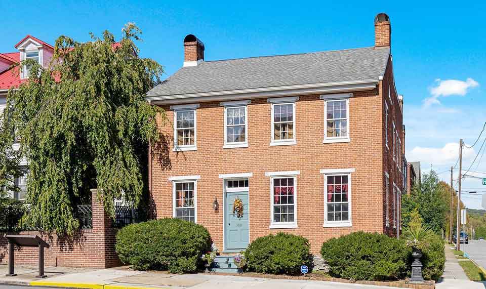
Wrightsville's more substantial houses line Front, Hellam, and Locust Streets, dating from as early as the 1790s. These are primarily brick or stone structures that loosely conform to specific architectural styles, though these styles appear somewhat later in Wrightsville than in more urban settings. Georgian and Federal style houses rise 2½ stories in brick or stone, generally appearing in the 2/3 Georgian townhouse form, though some larger five-bay structures exist. These houses very often display corbelled sawtooth brick cornice work and corbelled-brick gable rake boards, distinctive features that link them to Lancaster County traditions across the river.
Greek Revival influences manifested themselves through heavy projecting cornices, attic frieze windows, and front door sidelights, though these decorative elements were generally applied to Georgian and Federal structural forms rather than creating entirely new building types. The dominant post-Civil War style in Wrightsville's middle and upper-class housing is the Italianate, characterized by heavy bracketed wooden cornices and segmentally arched 2/2 windows topped by segmental lintels. Brick cornice work and corbelled segmental window hoods also appear frequently. As with the Greek Revival, Italianate ornamentation was typically applied to fundamentally Georgian forms. Other post-Civil War styles in Wrightsville include the Mansard, which occurs infrequently, and Shingle Style/Queen Anne, of which there are a few very fine examples.
Industrial architecture in Wrightsville, located primarily in the Front Street area, exhibits traits characteristic of nineteenth-century industrial construction. Buildings are generally brick on fieldstone foundations, rectangular in plan, 1½ to 3½ stories in height, and often banked into the sloping terrain. Exterior walls feature pilasters, with segmentally arched or jack-arched lintels and corbelled brick cornice work. The Wrightsville Hardware Company Complex on Water Street contains some unusual trapezoidal-shaped major buildings resulting from the railroad right-of-way bisecting the parcel diagonally. This complex also includes a large 2½-story weatherboarded-frame industrial building with tall, narrow windows topped by shallow-peaked lintel boards. While many of Wrightsville's late nineteenth and early twentieth-century industrial buildings, notably Riverside Foundry and Susquehanna Casting, have been demolished or drastically altered, the Wrightsville Hardware Complex, the McConkey Building, the silk mill, and the lime kilns still possess a high degree of integrity.
Architectural Distinction: Wrightsville represents the only concentration in York County of corbelled brick cornice work and window labels on residential buildings, motifs that occur frequently east of the Susquehanna in Lancaster County but are uncommon in the rest of York County. This distinctive architectural vocabulary reflects the town's close cultural and economic ties to the communities across the river.
Wrightsville's historical significance rests fundamentally on its role as a transportation center, beginning in the colonial period and extending through the railroad age. The settlement's location at a strategic crossing point of the Susquehanna River determined much of its subsequent history.
Wright's Ferry was in operation as early as 1730 between the sites of present-day Wrightsville on the west bank and Columbia on the east. In 1733, the Penn family issued a license to John Wright for the operation of his ferry, thus signaling the westward push of white settlers into what was to become York County. In addition to serving as the western terminus of one of the most important Susquehanna River crossing points, the settlement which became Wrightsville was also the eastern terminus of the Monocacy Road, which was extended southwestward into Maryland in 1739.
The towns of Wrightsville (north of Hellam Street) and Westphalia (south of Hellam Street) were laid out in 1811 and 1812 respectively. In 1814, three years after these adjacent towns were established, the first bridge to cross the mile-wide Susquehanna at this point was completed, making the crossing of the river easier for greater numbers of settlers and giving Wrightsville greater importance as a pass-through point as York County grew and prospered. Subsequent bridges were built in 1834, 1869, 1930, and 1972, of which only the 1930 and 1972 structures remain standing today.
Wrightsville became a focal point of canal transportation in south-central Pennsylvania in 1840 with the opening of the Susquehanna and Tidewater Canal, which had its northern terminus at the town. The canalization of the lower Susquehanna had been a bone of contention between the rival economic spheres of Philadelphia and Baltimore since 1820, and consequently it wasn't until 1835 that a bill chartering a canal company of Baltimore investors was able to overcome the opposition of Philadelphia interests in the Pennsylvania legislature.
By the time the 45-mile-long waterway was completed in 1840, it had cost $3,500,000. At $85,000 per mile—twice the norm—it was the third most expensive canal to be constructed before the Civil War. The Susquehanna and Tidewater was a commodious waterway, and this largeness of scale, in combination with the Chesapeake and Delaware Canal's southern access to Philadelphia across the Delmarva Peninsula, contributed to the decline of the older, smaller Union Canal, which linked the Schuylkill at Reading with the Susquehanna at Middletown. The most important products carried by the Susquehanna and Tidewater were coal and wood, and tolls collected peaked in 1855 at $211,141. The Susquehanna and Tidewater Canal Company operated the waterway until 1872, when operations were taken over by the Philadelphia and Reading Railroad. The canal ceased operations in 1896 after it was extensively damaged by a storm.
The York and Wrightsville Railroad was, like the Susquehanna and Tidewater Canal, largely a product of Baltimore interests. Indeed, five of the seven officials of the York and Wrightsville Railroad were Baltimore citizens. A line running from Baltimore to York had been proposed as early as 1827, largely as an alternative to Baltimore's beleaguered canal project. But, as with the canal, the Baltimore investors found their efforts blocked in the Pennsylvania legislature by Philadelphia interests. Finally, in 1832, a charter for the line was issued, and in 1835 the Pennsylvania legislature created the York and Wrightsville Railroad Company. By 1840, the line was completed.
Although Wrightsville had had a rail link with the State Works at Columbia since 1834, when tracks were laid on the Columbia-Wrightsville bridge, the new line expanded Wrightsville's horizons by providing rail links with Baltimore and Pittsburgh, and by putting the town on a major line to Philadelphia. The York and Wrightsville Railroad became part of the Northern Central system in 1854, which in turn became part of the Pennsylvania Railroad in 1870. The Columbia-Wrightsville bridge carried its last passenger train in 1954, while freight service continued until 1958. The tracks were then removed between Wrightsville and Hellam, and in 1964, the bridge itself was dismantled.
The Susquehanna and Tidewater Canal and York and Wrightsville Railroad provided an ease of access to raw materials and a convenience for distribution which made Wrightsville an ideal place for industrialization after 1840. The town's industries developed primarily along Front Street, near the canal and railroad, and preeminent among these were the lumber and metals industries.
Wrightsville's lumber industry involved the processing of raw timber, the sale and distribution of finished lumber, and the manufacturing of cigar boxes and builders' supplies such as doors, blinds, sashes, shutters, stairs, and other turned and scrolled items. The abundant forests of the Susquehanna watershed provided raw materials that could be floated downstream to Wrightsville's mills, where they were transformed into finished products and shipped to markets via canal and rail.
The metals industry involved the smelting of pig iron and the casting of hardware, toys, and novelties in bronze, brass, and iron. The foundries that lined Front Street took advantage of the transportation networks to bring in raw materials and ship out finished goods. Some of these foundries, including quarrying operations, remain in operation to this day, maintaining a direct link to Wrightsville's industrial past.
Other important nineteenth-century industries in Wrightsville included lime burning and quarrying, which took advantage of the limestone geology of the valley. The quarrying industry continues to this day, as evidenced by the active quarry on the ridge south of town. Cigar making became an important cottage industry, textiles employed many workers in the town's mill, and brick making supplied building materials for the growing region. The founding, quarrying, and textile industries all remained in operation as of 1983, providing continuity with the town's industrial heritage.
In June 1863, the south-central portion of Pennsylvania was in near chaos after the Confederate invasion of the Commonwealth. After June 16, refugees—which included farmers and their herds, free Blacks, and merchants—streamed north and east with their belongings to the principal Susquehanna River crossing points, one of which was at Wrightsville. The situation at Wrightsville became so desperate that trains could not pass on the bridge because of the throngs of people, livestock, and wagons laden with personal belongings that jammed the span and its western approach. The situation was greatly eased, however, when the owner of the bridge company, a Columbia banker, was persuaded to waive the collection of tolls, thus permitting a smooth flow of traffic.
Wrightsville had been emptied of refugees by the time Confederate forces entered the borough on June 28, 1863. A brigade of 2,400 men plus a battalion of cavalry under the command of General John B. Gordon were met at Wrightsville by several units of the Pennsylvania Militia. A small skirmish occurred, but the poorly trained, poorly equipped volunteers were no match for the more sophisticated Confederates, and under Confederate bombardment, they retreated across the bridge and set it on fire.
Historical Significance: The burning of the bridge at Wrightsville, along with the impending Battle of Gettysburg, effectively stopped General Gordon's plans to cross the Susquehanna to Lancaster County—a rich source of supplies for his men—and attack Harrisburg from the rear. Thus Wrightsville became the point farthest east that Confederate forces would reach during the Civil War.
The borough of Wrightsville was created in 1834 through the incorporation of two previously independent villages: Wrightsville (the area north of Hellam Street, laid out between 1811 and 1813) and Westphalia (the area south of Hellam Street, laid out in 1811 and 1812). The grid plan that characterizes both areas dates from the second decade of the nineteenth century and reflects the rational planning typical of the era.
Census figures indicate a substantial Black community in Wrightsville before and after the Civil War. This community likely found employment in the town's various industries and lived in the workers' housing that still characterizes much of the borough. The nomination form notes that Wrightsville's workers' housing could be a valuable resource in the socio-economic study of nineteenth-century free Black culture, representing a significant but often overlooked aspect of Pennsylvania's African American history.
The town was built for and by working people—those who operated the canal boats, stoked the foundry furnaces, worked in the sawmills, burned lime in the kilns, and broke stone in the quarries. The architectural fabric of Wrightsville, with its modest frame houses and substantial industrial buildings, preserves the physical environment of this working-class community and stands as testimony to the lives of ordinary Pennsylvanians during the state's industrial age.
The Wrightsville Historic District's period of significance spans from 1790 to 1920, encompassing the town's development from early settlement through the height of its industrial period. The district was listed on the National Register of Historic Places on July 29, 1983, in recognition of its significance in the areas of transportation, industry, architecture, and military history.
At the time of its nomination, the condition of buildings within the district ranged from excellent to ruins, with the majority in good condition. The district contained a mix of altered and unaltered buildings, with most structures remaining on their original sites. The area continued to function as a living community, with buildings still occupied and serving residential, commercial, religious, and park uses.
In Summary: The Wrightsville Historic District represents a significant and remarkably intact example of a nineteenth-century Penns—ylvania river town that served as a crucial transportation hub and industrial center. Its exceptional architectural integrity, from the modest workers' cottages to the substantial merchant houses and industrial buildings, reflects both its working-class origins and the distinctive regional building traditions imported from Lancaster County across the Susquehanna. The district preserves not only the physical fabric of a historic community but also the story of ordinary Americans who built their lives around the industries that transformed Pennsylvania during the nineteenth century.
† Adapted from: Jay Barshinger, Administrative Assistant at Historic York, Inc., Wrightsville Historic District, nomination document, 1983, National Register of Historic Places, Washington, D.C.
Street Names
2nd Street North • 2nd Street South • 3rd Street North • 3rd Street South • 4th Street North • 4th Street South • Apple Avenue • Barnes Avenue • Centre Alley • Cherry Street • Chestnut Street • Front Street North • Front Street North • Front Street South • Hellam Street • Howard Avenue • Junction Alley • Lemon Street • Locust Street • Maple Street • Middle Alley • Milldam Alley • Mulberry Street • Orange Street • Paw Paw Alley • Route 462 • Route 624 • South Alley • Spring Alley • Union Alley • Vine Street • Walnut Street • Willow Street • Wilton Circle